WRAL Weather Alert Day- Rainy Thursday evening commute, burn ban takes effect Friday morning
The Monday morning commute will be dry, but there is a chance for showers in the middle of the day.
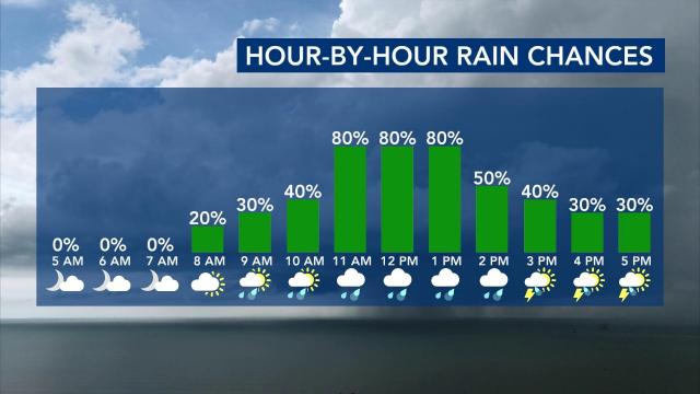
“The bulk of it will happen right around lunchtime,” WRAL meteorologist Elizabeth Gardner said.
Our best chance for rain will come between 11 a.m. and 1 p.m., but isolated showers and thunderstorms will be possible into the afternoon. Severe weather is not expected.
Instability is limited, meaning the only chance for thunderstorms will be during the afternoon south and east of Wake County.
Monday will be a mild day, with highs in the upper 60s to low 70s.

- Monday: Showers from 11 a.m. to 1 p.m. with some Sandhills storms later. Highs in the upper 60s/lower 70s.
- Tuesday: A mix of clouds and sunshine. Highs in the lower 70s.
- Wednesday: Mainly sunny with highs in the upper 60s.
Statewide burn ban
The North Carolina Forest Service issued a ban on all open burning and has suspended all burning permits statewide until further notice.
There are active wildfires in Polk and Caldwell Counties. Hundreds of acres continued to burn in the Green River Game Land on Saturday.
“It is spring wildfire season in North Carolina, and we are seeing wildfire activity increase due to dry conditions,” said Agriculture Commissioner Steve Troxler. “With these ongoing conditions, a statewide burn ban is necessary to reduce the risk of wildfires starting and spreading quickly.”
Critical fire conditions – a combination of winds gusting to 35 mph, low humidity and warm temperatures – were forecast for Saturday across the state.
Under North Carolina law, the ban prohibits all open burning in all 100 counties, regardless of whether a permit was previously issued. No new permits will be issued until the ban is lifted. Anyone violating the burn ban faces a $100 fine plus $183 court costs. Any person responsible for setting a fire may be liable for any expenses related to extinguishing the fire.
Going from spring to summer(ish) this week
High temperatures will be in the upper 60s and lower 70s Monday following any rain we see.
Rain totals will be around 0.1 inches for those that do see some.

That may briefly lower pollen levels before they spike again the rest of the week.

It won’t be overly warm during the work week. In fact, we’ve got a pair of chilly mornings Thursday and Friday, thanks to an area of high pressure sitting right over us.

Highs each day will be in the 60s and 70s, while morning lows dip into the 30s and 40s.

Once that high moves offshore, the southerly flow around it will force warmer air back into the area.
We’re tracking a warm-up that will likely bring our highs into the lower 80s for the final weekend of March.

This will help continue the migration of the ruby-throated hummingbird into North Carolina!
Get the feeders out!
Warming weather brings allergy season
With the warmth comes the pollen, and those who suffer from allergies should take note. As trees like juniper, elm and maple release their allergenic particles, tree pollen counts typically peaks in late March or early April.
We had lots of pine pollen early this week, so your cars may have a slight dusting in yellow color.
The pollen will be out in force over the next three days as well as we approach the first official day of spring.
Mold spores, which thrive in the damp of spring showers, also build up as the weather warms. Grass emerges more slowly, with grass pollen peaking in May.
7-day forecast for central NC
- Monday: More overcast with showers. Highs in the upper 60s.
- Tuesday: Partly cloudy. Highs near 71.
- Wednesday: Partly cloudy. High of 69.
- Thursday: Clear, colder, high of 63.
- Friday: Partly cloudy, breezy and warmer. Highs in the lower-mid 70s.
- Saturday: Windy and warm. Highs in the lower 80s.
- Sunday: Warm still with a chance of showers/storms. Highs near 80 degrees.
- Monday: Cloudy and warm. High of 79.

Source – Indonesia News